| Current Issue |
| View as PDF |
| features |
|
The Unforgiving Sky |
| Heart of a Hunter |
| regulars |
|
Valley View:
Craters of the Moon |
| Sun Valley Guides |
|
Chefs
Specialty: Pear Particulars |
| Last Exit |
| information directory |
| calendar |
| Fall Festivals |
| listings |
| Galleries |
| Dining |
| Luxury Living |
|
Lodging,
Outfitters/ Guides & Equipment |
| maps |
|
Ketchum
& Sun Valley |
| Gallery Map |
| the guide |
| Last Summer |
| Last Winter |
| Last Fall |
| Contact Us |
|
About
Us/ Contributors |

|
|
Copyright © 2008 Express Publishing Inc. All Rights reserved. Reproduction in whole or in part in any form or medium without express written permission of Express Publishing Inc. is strictly prohibited. The Sun Valley Guide magazine is distributed free four times a year to residents and guests throughout the Sun Valley, Idaho resort area communities. Subscribers to the Idaho Mountain Express newspaper will receive the Sun Valley Guide with their subscription. |

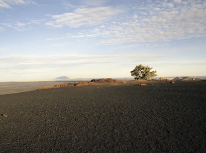
Photo by Kirsten Hepburn
Valley View: Craters of the Moon
...one giant leap for
mankind
a small step to Craters of the Moon
Drivers heading east out of Carey will see familiar views of sage-covered plains and irrigated farm fields abruptly end. A vast and forbidding sea of contorted black lava erupts on both sides of U.S. Highway 20 and flows south to the horizon.
Welcome to Craters of the Moon National Monument, a crescent-shaped lava field nestled against the foothills of the Pioneer Mountains and extending 60 miles south to the rim of the Snake River canyon. Straddling a fissure in the earth called the Great Rift, the monument’s 618 square miles encompass the largest young lava field in the continental U.S.
There’s an amazing array of volcanic formations here: spatter cones, cinder cones, fissure vents, raft blocks, lava tubes and caves. Lava formations include ropy, twisted flows called "pahoehoe" and chunky fields called "aa," which means "hard on the feet." Both names originate from Hawaiian volcano studies. Still more lava "bomb" forms have evocative names like "cow dung" and "breadcrust."
In 1969, NASA sent Apollo astronauts here on a lunar training mission. To appreciate the scale of this massive zone of molten stone, they likely scrambled up 820-foot Big Cinder Butte, the park’s highest point. From atop the broad peak, you can follow the Great Rift’s southeasterly line by the chain of cinder cones fading away into the distance. To the east, the Big Southern Butte rises out of the desert. At 2,500 feet, the volcanic dome served as the dominant landmark for Oregon Trail pioneers short-cutting the Snake River Plain. To the north, vistas of snow-capped Lost River and Lemhi mountain peaks are framed by the gnarled, wind-sculptured branches of limber pine.
Based on geologic history, another eruption is due within the next millennium, perhaps as soon as 200 years from now.
Stay tuned.
—Ken Retallic